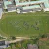
Penglais school - map of the world, 2007
Gellir lawrlwytho cynnwys at ddibenion anfasnachol, megis at ddefnydd personol neu mewn adnoddau addysgol.
At ddibenion masnachol cysylltwch â deiliad yr hawlfraint yn uniongyrchol.
Read more about the Trwydded Archif Greadigol.
Disgrifiadau
Penglais Comprehensive School, 1500 pupils in the form of the World Map. Taken from the air in 2007.
Ref:AP_2007_0847
Uwchlwytho gan
Dyddiad Ymuno:
24/07/2009
Eitem wedi’i llwytho:
25/9/2013
Gwelediadau:
2473
Ffefrynnau:
0
Related items
-
Awyrluniau o Arfordir Bro MorgannwgEitemau 16 itemsMath CasgliadauUwchlwytho gan Llyfrgelloedd Bro Morgannwg -
Awyrluniau o Benarth, Dinas Powys a LlandochauEitemau 10 itemsMath CasgliadauUwchlwytho gan Llyfrgelloedd Bro Morgannwg -
Awyrluniau o Ddociau'r Barri ac Ynys y BarriEitemau 24 itemsMath CasgliadauUwchlwytho gan Llyfrgelloedd Bro Morgannwg -
Awyrluniau o drefgordd y BarriEitemau 7 itemsMath CasgliadauUwchlwytho gan Llyfrgelloedd Bro Morgannwg -
Awyrluniau o'r Fro WledigEitemau 15 itemsMath CasgliadauUwchlwytho gan Llyfrgelloedd Bro Morgannwg -
Aerial View of Barry No.1 DockMath EitemauUwchlwytho gan Llyfrgelloedd Bro Morgannwg -
Aerial View of Barry Dock EntranceMath EitemauUwchlwytho gan Llyfrgelloedd Bro Morgannwg -
Aerial View of Barry No.2 Dock and Ranks MillMath EitemauUwchlwytho gan Llyfrgelloedd Bro Morgannwg -
Aerial View of Nell's Point and Whitmore BayMath EitemauUwchlwytho gan Llyfrgelloedd Bro Morgannwg -
Aerial View of Biglis to Friars PointMath EitemauUwchlwytho gan Llyfrgelloedd Bro Morgannwg
Cysylltwch â Ni
I wneud cais i dynnu i lawr neu riportio cynnwys hiliol, sarhaus neu niweidiol mewn unrhyw ffordd arall.
You must be logged in to leave a comment