Prima Europe tabula
Prima Europe tabula
Disgrifiadau
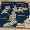
One of the earliest surviving copies of Ptolemy's 2nd century map of the British Isles. Originally published in Ptolemy's Geographia. This is the second issue of the 1482 map, also printed at Ulm, which was the first woodcut map of the British Isles and the first to be printed outside Italy.
Ffynhonnell allanol:

Cysylltwch â Ni
I wneud cais i dynnu i lawr neu riportio cynnwys hiliol, sarhaus neu niweidiol mewn unrhyw ffordd arall.

You must be logged in to leave a comment