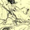
1836 Plan of Pontypool
Disgrifiadau
This map clearly shows the river and canal, the industrial sites and the commercial centre of Pontypool clustered around The Cross, and sites such as Blue Boar Fields which became the site for the Market building in 1890's.

More items with these tags
Mae'r eitem hon hefyd yn ymddangos yn

Cysylltwch â Ni
I wneud cais i dynnu i lawr neu riportio cynnwys hiliol, sarhaus neu niweidiol mewn unrhyw ffordd arall.

You must be logged in to leave a comment